Cittadini | Imprese | Versione grafica
Facebook | Twitter | Youtube | RSS
The Institutional Board of the regional Basin Authority of Central Campania approved Map of Endangered Areas and flood risks.
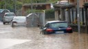
The survey proved that 44 sq. Km, namely 2.1 % of the area under the responsibility of the Authority, that involves 182 Municipalities of Campania and in details, includes Naples, Caserta, the areas of Sarno, Nocera, Castellammare di Stabia, and Torre Annunziata, the so-called “Vesuviani” towns, Sorrento coastal towns, the islands of the Gulf and the “Alta Solofrana” area are very highly endangered with a R4 level and 72 sq. Km are highly endangered, with a R3 level.
The achievement is the result of the cooperation among the Sector for Soil Conservation of the Regional Administration for Civil Protection of Regione Campania and the two regional Basin Authorities, that have been debating and working with the National Basin Authority Liri-Garigliano-Volturno that, led by Ms. Vera Corbelli, coordinates the Plan.
Regional Minister for Civil Protection Edoardo Cosenza stated: “This is an important achievement: these are the first maps for Campania and the Hydrographical District of the Southern Apennines to be defined before the law deadline set on 22 June. This allows us to assess risk exposure of those Municipalities affected by the tragic event of 5 May 1998”.
Commissioner for the Basin Authority of Central Campania Pasquale Marrazzo added: “ It is fundamental to point out that the whole work, namely the drafting of 400 charts and a technical explanatory report, has been carried out by the technicians of the Authority with no costs for Regione, and the Regional Administration responsible for civil protection along with the National Basin Authority have been constantly supporting this activity”.
Regione Campania (Codice Fiscale 800.119.906.39)
Sede legale: via S. Lucia, 81 - 80132 Napoli
Sede Centro Direzionale Isola A6 +39 081 796 61 11
Sede Centro Direzionale Isola C3-C5 +39 081 796 91 11